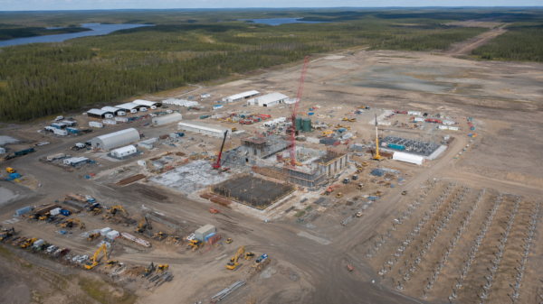
Skyharbour Resources (TSXV: SYH) (OTCQX: SYHBF) (Frankfurt: SC1P) announced the acquisition of eight new uranium exploration properties in the Athabasca Basin of northern Saskatchewan on Monday.
These eight properties span 34,022 hectares (or 85,070 acres) in the basin, and increase the company’s total land package to 492,074 hectares across twenty-three properties. These properties are prospective for rare earth elements, as well as basement-hosted unconformity-related and/or intrusive-type uranium mineralization.
The new properties will become part of Skyharbour’s prospect generator business, with the company seeking strategic partners to advance these assets while it focuses on its ongoing 10,000 meter drill program at the Russell Lake project. These properties have no underlying royalties or encumbrances on them.
The recently staked Highway Project, located 41 kilometers south of the Rabbit Lake Mine and 11 kilometers southwest of Uranium Energy Corp’s (NYSE: UEC) West Bear uranium and copper-nickel Deposits. It’s relatively underexplored despite its proximity to infrastructure and excellent access.
The project is underlain by prospective Wollaston Supergroup metasedimentary gneisses and is believed to be covered by Athabasca sandstone in the past. The project is prospective for rare earth elements (REEs) in addition to basement-hosted unconformity-related and/or intrusive-type uranium mineralization.
Between 1968-1978, the Highway Project underwent early exploration work that included airborne electromagnetic (EM), magnetic, and radiometric surveys, bedrock mapping, prospecting, radon sampling, and ground EM surveying on portions of the property, as well as a single augered drill hole. The project was also covered by portions of airborne EM and magnetics surveys in 2009, 2011, and 2017.
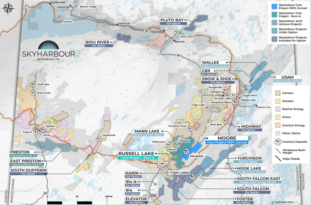
Project portfolio map. Map via Skyharbour Resources.
Read more: SKRR Exploration enters LOI to acquire 70% in uranium exploration project
Read more: Basin Uranium and Skyharbour Resources find significant mineralization at Mann Lake
Historical EM conductors find anomalous uranium and REE at T-Lake
Southwest of the property, there are historic EM conductors at “T-Lake,” where surface sampling and historic diamond drilling encountered anomalous uranium, and rare earth element graphitic faulting and variably altered fracture zones.
The EM conductors at T-Lake coincide with a northeast-trending magnetic low along the Archean-Wollaston Supergroup contact, which extends onto the Highway property and is folded around the Archean gneiss dome before continuing off the property to the southwest along the northern fold limb.
Additionally, the northern fold limb off the property is associated with EM conductors north of Robertson Lake and by Dorward Bay, and with off-conductor uranium and thorium mineralization at the “Manhattan Showing.”
In 2011, ground prospecting on the Highway property encountered a pegmatite-pelitic gneiss boulder containing concentrations of 3475 parts per million (ppm) REE, ytrium and scandium, suggesting the Highway Project is prospective for REE in addition to basement-hosted unconformity-related and/or intrusive-type uranium mineralization.
The Snow, Shoe, and CBX properties are three non-contiguous claims covering 2,582 hectares located in the northern end of Wollaston Lake, approximately 10 to 25 kilometers northeast of Cameco’s Rabbit Lake Operation.
Previous work done on the properties mostly between 1968 and 1981, with some additional work in 1993, includes airborne EM, magnetics, and radiometrics surveys, marine seismic, prospecting, geological mapping, and geochemical sampling. A Heli-TDEM and magnetic survey was flown in 2007, but no modern exploration has been done on the properties themselves.
A 1978 Mk VI INPUT EM survey identified several historical conductors on or along the trend of the properties. No diamond drilling or modern ground geophysical surveying has been done on the projects. The properties have potential for unconformity-related, basement-hosted uranium mineralization as well as pegmatite- and granite-hosted uranium and REEs. The CBX property is also prospective for molybdenite, as sedimentary-hosted molybdenite and pyrite were identified in fractures in a quartzite outcrop on the property.

Sky highway project map. Map via Skyharbour Resources.
Read more: CanAlaska Uranium starts $10M winter drill program in Athabasca Basin
Read more: Uranium Energy Corp secures $18M supply agreement with U.S. government
Four claims close to major highway provide easy access
The 914, 914N, and Elevator projects comprise of four claims covering a total of 11,873 hectares. They are situated 31 to 52 kilometers south of the margin of the Athabasca Basin and 35 to 55 kilometers south of Cameco’s Key Lake Operation, which has produced 209.8 million pounds U3O8 at an average grade of 2.32 per cent.
All three projects are located near Provincial Highway 914, with the 914 Project positioned 1 kilometer east of Highway 914, the 914N Property situated 5 kilometer east of Highway 914, and the Elevator Property situated 15 kilometer east of Highway 914.
The properties and the surrounding areas are underlain by promising Wollaston Supergroup metasedimentary gneisses and Archean granitic to tonalitic gneisses of the Western Wollaston Domain, which have hosted significant uranium mineralization farther north in the Athabasca Basin. Geological mapping has confirmed the prospectivity of these rock formations in the projects.
During the 1970s, significant work was conducted on the properties and surrounding areas, which included magnetic, gravity, and EM surveys, as well as geological mapping, prospecting, boulder, and sediment sampling programs.
However, in recent times, modern work has been limited to partial coverage by an airborne VTEM survey, ground prospecting, and lake sediment sampling. Although an EM conductor was identified on the 914N property, it has not been drill tested, and the rest of the properties were not covered by modern geophysical surveys.
According to historical bedrock mapping conducted by the Saskatchewan Geological Survey, all four claims are situated on the edge of regional scale folds. Recent regional airborne magnetic surveys reveal additional complexity that was not reflected in the historical bedrock mapping.
Despite there being no uranium discoveries on the properties themselves, there are multiple uranium and REE showings in the surrounding area, including the Sandra Lake, Key Lake Road, Karpinka Lake, and Don Lake occurrences. These showings share similar stratigraphy to the Athabasca Basin where significant uranium and thorium mineralization is found.
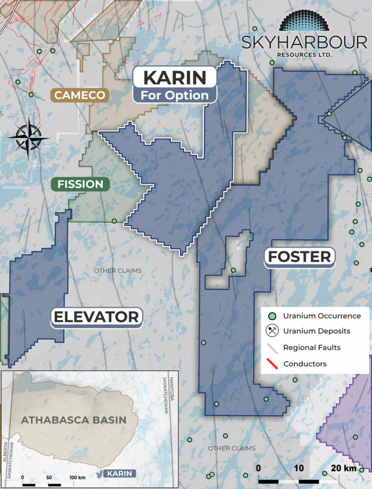
Karin Project Map. Map via Skyharbour Resources.
The Karin Project consists of five claims covering 18,383 ha located about 20 kilometers south-southeast of Cameco’s Key Lake operation and adjacent to Skyharbour’s Foster Project. The property is east of Highway 914, ranging from approximately 21 to 33 kilometers away.
It is underlain by Wollaston Group metasedimentary gneisses of predominantly psammitic to meta-arkosic composition with localized pelitic to psammopelitic gneisses that are prospective for unconformity-related uranium mineralization, despite being outside the current extent of the Athabasca Basin.
The exploration work done on the project is mostly historical, carried out from the late 1960s to the early 1980s, and includes airborne EM, magnetic, and radiometric surveys, lake water and sediment sampling, radon surveys, prospecting, and diamond drilling.
While some minor EM anomalies were noted in the historical airborne EM results, they were ignored in favor of stronger EM anomalies elsewhere in the surveyed areas. The project area has not been explored since the 1980s, except for a limited amount of prospecting in 2008 that led to the discovery of an outcrop of pegmatite on the property containing uranium, niobium, and tantalum.
Five shallow diamond drill holes were drilled on the project in 1978, intersecting Wollaston Supergroup meta-arkose and semipelitic to pelitic gneisses, amphibolite and pegmatite to granodiorite, and localized hematite, chlorite, epidote, and/or goethite alteration.
Weakly radioactive pegmatite was intersected in historical hole 78-1, which returned 0.025 per cent U3O8 over 0.45 meters at a depth of 72.85 meters. Several radon anomalies were discovered on the eastern part of the project during radon sampling, and these were followed up by drilling. The Karin Project is prospective for both intrusive-type and unconformity-related uranium deposits and intrusive-related REEs.
Skyharbour Resources shares dipped 5.8 per cent to $0.32.5 on the TSX Venture Exchange.
Follow Joseph Morton on Twitter
joseph@mugglehead.com